Bosnia has been inhabited at least since Neolithic times. In the early Bronze Age, the
Neolithic population was replaced by more warlike tribes known as the Illyres or
Illyrians. The Illyrians spoke an Indo-European language.
In the year 168 BC the land of Illyres became the Roman province of Illyricum. In year 10,
following a four-year rebellion of Illyres, Illyria was divided and the northern strip of
today's Bosnia along the south side of the Sava river became part of the new province of
Pannonia, while the rest of what is today Bosnia, Herzegovina, Montenegro, Dalmatia,
western Serbia became part of the Roman province of Dalmatia.
Latin-speaking settlers from all over the empire settled among the Illyrians, and Roman
soldiers were encouraged to retire in the provinces of Dalmatia, Pannonia, and Dacia
across the river Danube. The town of Blagaj on the Buna River is built on the site of the
Roman town of Bona. Illyria and Pannonia were later included in the Western Roman Empire
(following events from the years 337 and 395 when the Empire split).
The Romans lost control of Pannonia and Dalmatia in 455 to the Ostrogoths. The Ostrogoth
Kingdom was defeated by Eastern Roman Empire in the 'Gothic War' from 535-553 by the
Emperor Justinian, and for a time in the mid-Sixth Century the Dalmatian province became
part of the Eastern Roman Empire.
The Slavs, who had originated in areas spanning modern-day southern Poland, were
subjugated by the Turkic Avars in the 6th century, and together they invaded the Eastern
Roman Empire in the 6th and 7th centuries, settling in what is now Bosnia, Herzegovina,
and the surrounding lands. The Serbs and Croats came in a second wave, invited by Emperor
Heraclius to drive the Avars from Dalmatia.
Around 925, Bosnia was briefly ruled by Tomislav, the king of Croatia. From the 930's to
the 960's eastern Bosnia, together with part of western Serbia, was ruled by Serbian
Prince Časlav Klonimirović, who liberated his state from Bulgarian rule and acknowledged
the sovereignty of the Byzantine Empire.
The first mention of the name "Bosnia" is in the De Administrando Imperio of
Byzantine emperor Constantine Porphyrogenitus in 958. Heading 32 of the De Administrando
Imperio describes the territories under Serbian control, in which he mentions the
"small region" (χοριον) of "Bosona" (Βοσωνα), in which lie
the two inhabited cities, Kotor and Desnik. Though the location of Desnik is still uknown,
Kotor was located to the south of present day Sarajevo. In the early Middle Ages, the term
Bosnia described the region of the Bosna river valley. Later this term spread to cover
most of what is today Bosnia and Herzegovina.
In 1019 the Byzantine Emperor Basil II forced Serb and Croat rulers to acknowledge
Byzantine sovereignty. Croatian king Petar Krešimir IV who rose to power in the 1060s
exerted influence over Bosnia. Prince Mihailo of Zeta (also known as Duklja), took control
of Hum (Herzegovina), and declared his independence from the Byzantine Empire before 1077.
Mihailo was crowned as King of Serbia by Pope Gregory VII. Mihailo's son Konstantin Bodin
conquered much of Bosnia after 1083, but his rule of Bosnia lasted only a short time, and
discord among his heirs led to the breakup of the kingdom shortly after his death in 1101.
The Charter of Kulin, 1189When Croatia became part of the Hungarian kingdom in 1102, most
of Bosnia became vassal to Hungary as well. Since 1137, Bela II of Hungary claimed the
duchy of Rama, a region of northern Herzegovina. His title included "rex Ramae"
since 1138, likely referring to all of Bosnia. However, by the 1160s the Byzantine Emperor
Manuel I Comnenus defeated Hungary and restored Bosnia to the Eastern Roman Empire for a
time.
There are various historic documents that include unclear or conflicting information as to
the ethnic identity of the inhabitants of medieval Bosnia. For example, the Chronicle of
the Priest of Duklja (Ljetopis popa Dukljanina), created around 1172-1196 mentions Bosnia
(Bosnam) as one of the two Serbian lands, while describing the four southern Dalmatian
duchies (including most of today's Herzegovina) as Croatian lands, a description rather
inconsistent with other historical works from the same period. Coupled with other
inaccurate or simply wrong claims in the text, it cannot be considered reliable.
After some centuries of rule by Croatia, Serb principalities, and the Byzantine Empire, an
independent Bosnian state flourished in central Bosnia between the twelfth and the
fifteenth centuries.
http://sokolac.slavicnet.com/sokolac/sokolac_history_forum.html
GRAD DESNIK I BOSNA
„Οτι εν τή βαπτισμένη Σερβλία είσίν κάστρα
οίκούμενα' το Δεστινίκον , το Τζερναβουσ κέη, το
Μεγυρέτους , το Δρεσνεήκ, το Λεσνήκ, το Σαληνές
και εις τo χωρίον Βόσονα το Κάτερα και το Δεσνήκ”.
И ПРЕМА СЕЛУ БОСОНА (και εις το χωριον Βοσονα)
Катера и Десник (το Κατερα και το Δεσνηκ)”.
The first mention of the name "Bosnia" is in the De Administrando Imperio of
Byzantine emperor Constantine Porphyrogenitus in 958. Heading 32 of the De Administrando
Imperio describes the territories under Serbian control, in which he mentions the
"small region" (χοριον) of "Bosona" (Βοσωνα), in which lie
the two inhabited cities, Kotor and Desnik.
Kazu da mjesto grada Desnika jos nije odredjeno. Jedni ga lociraju ovdje, drugi ondje, a
treci kazu: Desnik je bio u blizini danasnjeg Kaknja! A Petko N. Vidusa je od Kaknja, sa
Viduse, odmah ispog ostataka zidina drevnog grada Desnika
Pa da prosetamo malo do "nelociranog" grada Desnika.
Geografski polozaj grada Desnika:
http://www.fallingrain.com/world/BK/1/Vidusa.html
Geografski polozaj grada Desnika: Kicin Greb je mala zaravan od koje se istocno uzdize
Kulen, mjesto grada Desnika: http://www.fallingrain.com/world/BK/1/Kicin_Greb.html
Selo Bosna (Konstantinova Bosona), 100% cisto srbsko selo etnicki ocesceno i popaljeno u
zadnjem ratu). Tu u zivjeli Srbi sa prezimenom
Bosnjaci:http://www.fallingrain.com/world/BK/1/Bosna.html
Selo Desetnik (prije rata vecinsko muslimansko selo) jos nosi ime po gradu Desniku (nalazi
se na oko 1,5 km sjeveroistocno od grada Desnika):
http://www.fallingrain.com/world/BK/1/Gornji_Desetnik.html
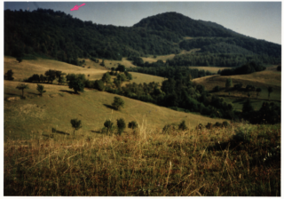
Pogled iz sela Viduse na vis Kulen, mjesto grada
Desnika (oznaceno strelicom).
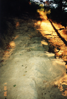
Ostaci temelja zidina grada Desnika
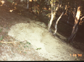
Ostaci zidina Desnika
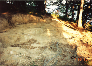
Ostaci temelja zidina grada Desnika.
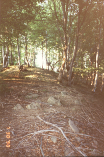
Vrh Kulena
(Tekst i snimci Petko Nikolic Vidusa)
http://www.mycity.rs/Istorija/Porfirogenitov-grad-Desnik-i-zemlja-Bosna.html